One-tap hazard check: master toggle, Perth address search & scenario presets
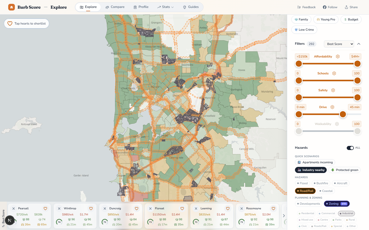
Due diligence on a Perth property used to mean reading the WAPC's State Planning Policy library, decoding DWER flood maps, cross-referencing DFES's Bushfire Prone Map, and hoping you hadn't missed an ANEF contour from Perth Airport. We turned all of that into one tap.
The master hazard toggle
At the top of every Hazards panel — on the Explore map and on every suburb profile page — there is now a single master switch. Flip it once and every hazard and planning layer comes on at the same time. The suburb-level colour heatmap fades so the overlays are legible. Flip it back and you're in normal score-browsing mode. One tap to go from "browsing suburbs" to "investigating risk".
Address search — the feature everyone actually wants
The master toggle is for browsing. The address search is for deciding.
Type any Perth street address into the hazard panel. We geocode it via Photon (OpenStreetMap-backed, privacy-respecting, no API key leaked to your browser), fly the map to the exact point, drop a pin, and pop up a point-level hazard summary — not the suburb average, but the specific lot. If your address touches a flood fringe polygon, the popup says so. If it's inside an ANEF 25 contour, the popup tells you the expected noise impact. If it's in an industrial zone, it says so.
The popup covers every active layer at once — flood, bushfire, aircraft noise, road/rail noise, coastal setback, zoning, R-code, whether a Structure Plan or DBCA Reserve overlaps the point. Each line is colour-graded — green for "no overlap", amber for "minor", red for "significant" — so you can eyeball a risk profile in under a second.
Three real-world examples from the live data:
- A riverside Applecross address might return: flood 20% (moderate — flood fringe), bushfire none, aircraft ANEF 20 (acceptable), road/rail none, R25 (single house / duplex), zoning Residential.
- An Ellenbrook new-build address might return: flood none, bushfire extreme (DFES-designated), aircraft ANEF 20 (minor), Structure Plan: 12,500 dwellings planned.
- A High Wycombe address near the airport: aircraft ANEF 30 (significant noise impact), R20, industrial zoning 400m east.
Percentage-based suburb summary rows
On every suburb profile, the hazard summary card used to be a mix of booleans, counts, and area percentages. That made comparison awkward — you couldn't compare "bushfire prone" (true / false) to "flood zone" (6% of suburb) on the same scale.
Every layer's summary row now reports percentage of suburb area inside the hazard zone, on the same colour-graded 0–100% scale, with the same four status tiers (None · Minor · Moderate · Significant). The thresholds come from a tercile analysis across all Perth metro suburbs, so "significant" genuinely means "in the top third for this risk".
The same approach applies to the new planning layers. On any suburb profile you can now see at a glance that Baldivis has 14% of its area zoned industrial, or that Yanchep has 90% of its area in Bush Forever and DBCA reserves.
Every tooltip got a rewrite
We've shipped the overlays before (see the April 12 release) but the first cut used the raw polygon attribute names — zone codes, scheme numbers, ANEF bands — which read like bureaucratic jargon to anyone outside a planning department. Every tooltip across all 12 layers has now been redesigned around plain English.
Examples of what you used to see vs what you see now:
- Old:
R40. New: "R40 — Min lot 180m² · avg 220m² · Grouped dwellings, villa, townhouse · ~40 dwellings/ha". - Old:
ANEF 25. New: "ANEF 25 · Perth Airport · Moderate noise — conditional residential". - Old:
floodway. New: "Floodway — no building permitted · Swan River · Study: 2018". - Old:
Residential Reserve. New: "John Forrest National Park · Class A — highest protection · Conservation Commission · Conservation and Land Management Act 1984 · 2,681 ha".
Mobile UX
The hazard panel now opens from its own tab on the mobile filter sheet (instead of being tucked at the bottom of the full-height scroll). Address search, master toggle, presets, and per-layer pills all fit in one thumb-reachable view on an iPhone 15.
Why this exists
Property buying advice in Perth consistently identifies flood, bushfire and aircraft noise as the three big physical-risk items people wish they'd checked before settlement. But the data has historically been buried across multiple .gov.au websites with different URL structures, different login requirements, and different polygon formats. The frustration was real, and the solution had to be one-tap or nobody would use it.
Try it: go to /explore, open the Hazards panel, and search a Perth address you know well. Then search one you're considering.
Want to know when we ship something new?
Join the newsletter — no spam, just feature updates.