R-Codes Explained: What R20–R80 Zoning Means in Perth
Zoning decides what a block of land can become: one house, a duplex, six villas, or an apartment building. It's arguably the single biggest determinant of a property's long-term value after location itself. Yet most Perth buyers find out what their block allows after settlement, usually when a neighbour lodges plans for a triplex. Investors and developers check before they bid. This guide gets you into the second group.
One thing worth saying up front: almost everything written about R-Codes online is published by subdivision companies, and subdivision companies have an obvious interest in convincing you your block is a goldmine. We don't subdivide anything; we map data. This page explains what the codes actually say, where the paper potential meets reality, and how to check any Perth property's coding yourself in about ten seconds.
What are R-Codes?
R-Codes are Western Australia's Residential Design Codes, a state-wide rulebook that sets how many dwellings can sit on a block of residential land and how they must be designed. Every residential property in WA carries a density code, from R2 (rural-sized lots) up to R-AC (apartments in activity centres).
The 'R' number is shorthand for dwellings per hectare: R20 targets roughly 20 dwellings per hectare, R60 roughly 60. The codes were long known as State Planning Policy 7.3 (SPP 7.3), and you'll still see them cited that way everywhere. Since April 2024 the Residential Design Codes Volume 1, published by the Western Australian Planning Commission and the Department of Planning, Lands and Heritage, has operated as a standalone Planning Code (subsidiary legislation under the Planning and Development Act), which gives it more legal weight than an ordinary policy. The current edition is Version 3, published 10 April 2026.
The split between the two volumes matters. Volume 1 covers single houses and grouped dwellings (villas, townhouses, duplexes) at all codes, plus small apartment developments coded R10–R60. Volume 2 covers apartments at R80 and above and in R-AC areas. If you're reading this to work out whether you can fit a second dwelling on a suburban block, Volume 1 is your document.
Here's the part that confuses people: the state writes the rulebook, but your local council applies the codes through its local planning scheme. The scheme map, not the R-Codes document, is what assigns R20 to your street and R60 to the street near the train station. Changing a code requires a scheme amendment: council resolution, public consultation, and final approval by the Minister for Planning. That's why two identical blocks in adjoining suburbs can carry completely different development rights.
What does each R-Code actually allow?
The number after the R is dwellings per hectare, but the practical rule is the site-area table: each code sets a minimum and average site area per dwelling. Divide your block size by the average site area and round down; that's the maximum dwelling yield the code allows on your land.
These figures come from the site-area table of the Residential Design Codes Volume 1 (titled simply Table 1 under SPP 7.3, now Table D in the 2026 edition). They apply to single houses and grouped dwellings:
| Code | Min site area per dwelling | Average site area per dwelling | What fits on a typical 700–900m² block |
|---|---|---|---|
| R5 | 2,000m² | No average applies | One house. This is a semi-rural code, and a standard suburban block is well under the minimum for any subdivision. |
| R10 | 875m² | 1,000m² | One house. Two dwellings needs 2,000m², so most blocks stay as they are. |
| R20 | 350m² | 450m² | One house under 900m². At 900m² or more, two: the classic duplex or battleaxe split. |
| R25 | 300m² | 350m² | Two dwellings from 700m². Three needs 1,050m². |
| R30 | 260m² | 300m² | Two on 700m²; three from 900m². |
| R40 | 180m² | 220m² | Three on 700m²; four from 880m². |
| R60 | 120m² | 150m² | Four to six dwellings, depending on exact size. |
| R80 | 100m² | 120m² | Five to seven on paper, though at this density apartments usually make more sense than villas. |
Two reading notes. First, the average governs yield and the minimum governs the smallest individual lot; you need both to work. A 700m² R20 block clears two minimums (2 × 350m²) but fails the average test (2 × 450m² = 900m²), so it stays a one-dwelling block. Second, apartments (multiple dwellings) use different, smaller averages under the medium-density standards in Part C of the codes. At R60, for instance, the average drops to 85m² per apartment. Codes above R80 (R100, R160, R-AC) apply R80 site areas to houses and send apartments to Volume 2 entirely.
What does dual-coded zoning like R20/40 mean?
A dual code like R20/40 means the lower code applies by default, and the higher code only applies if your development meets extra conditions set out in the council's planning scheme or local planning policy. Typical conditions include connection to reticulated sewer, proximity to transport or centres, or specific design requirements.
Dual coding is how councils hedge. They want infill in the right spots without rezoning entire suburbs outright, so they grant the upside conditionally. The conditions vary by council (there is no state-wide list), which means the only reliable way to know whether your R20/40 block can actually be developed at R40 is to read the relevant local planning policy or ask the council's planning desk. Some councils make the higher code near-automatic if you're on sewer; others attach design criteria strict enough that few applications bother.
Perth's north-eastern middle ring is the classic dual-coding belt: City of Stirling suburbs like Balga, Nollamara and Westminster carry extensive split codings, which is exactly why those suburbs have spent two decades filling with triplex and villa developments while neighbouring single-coded streets haven't changed. When a listing says "R20/60, development potential!", the honest translation is: R20 today, R60 if the council's conditions are met, and you should verify which conditions before paying for the difference.
What's the difference between zoning and R-Codes?
Zoning is the broad land-use category your local planning scheme assigns: residential, commercial, mixed use, industrial. R-Codes are a density layer that applies within zones that allow housing. Two suburbs can both be zoned "Residential" yet allow completely different development because one is coded R20 and the other R60.
Think of it as two questions the scheme answers separately. The zone answers what can this land be used for: a house, a shop, an office, a mix. The density code answers how much housing fits here. A "Mixed Use R80" parcel near a train station can take shops with apartments above; a "Residential R20" parcel three streets away takes one house per 450m² and nothing else. Industrial and most commercial zones carry no R-Code at all, because nobody is meant to live there.
In practice the distinction matters most at the edges: corridors and centres where councils rezone residential land to mixed use, attach a high R-Code, and quietly transform a strip of old houses into five-storey development sites. The zone change is the signal; the R-Code is the magnitude.
What is a structure plan?
A structure plan is a forward-looking blueprint for an area that hasn't been fully developed yet: urban-fringe growth fronts and major infill precincts. It sets out future roads, schools, open space and residential density codes before subdivision happens, so it signals tomorrow's R-Codes before they're formally applied.
Structure plans over the Brabham and Aveley growth front. Click to open the live layer.
Structure plans are prepared by landowners or councils and approved by the Western Australian Planning Commission, and they're the standard mechanism for converting broadacre land into suburbs in growth corridors like Alkimos, Brabham, Byford and Haynes. The plan shows which future streets get R25 cottage lots, which get R40 terraces, and where the future town centre's R-AC coding will land, years before any of it is gazetted into the local planning scheme. The state's Urban Land Development Outlook (DPLH's Urban Development Program) tracks how this pipeline converts into actual lots and dwellings.
For buyers, structure plans answer a question current zoning can't: what will this area become? A paddock coded "Urban Development" tells you almost nothing; the structure plan over it tells you the density, the school sites and the main road alignments. If you want to see which Perth suburbs have the most of this future supply coming, we ranked them in our development pipeline analysis.
What doesn't an R-Code tell you?
An R-Code is paper potential. Site constraints can make the maximum yield unbuildable: bushfire ratings, flood zones, heritage listings and sewer availability all override what the density table promises. Before paying a premium for "subdivision potential", check what else applies to the block.
The usual suspects, roughly in order of how often they kill a project:
- Sewer availability. Most councils require reticulated sewer for subdivision below ~R20 lot sizes, and large parts of Perth's older middle suburbs still aren't connected. An R40 coding on an unsewered street is decorative.
- Bushfire-prone designation. Mapped bushfire-prone land triggers BAL (Bushfire Attack Level) assessment, and high ratings add construction cost or rule out development outright. We've ranked the most bushfire-prone Perth suburbs. Several carry generous codings that are hard to use.
- Flood zones. Floodway land along the Swan, Canning and lesser rivers is effectively undevelopable regardless of coding; flood-fringe land needs fill and raised floor levels.
- Heritage listings. A state or local heritage listing constrains demolition and can sterilise the density a code theoretically grants.
- Retained-dwelling rules. Keeping the existing house while subdividing the back sounds free, but the retained dwelling must still meet setbacks and open-space standards at the new density. Plenty of battleaxe plans die here.
And some land is simply never in play: Bush Forever sites and DBCA-managed reserves are permanently protected, no matter what density coding sits nearby. You can see both on the BurbScore protected land layers, and our greenest suburbs analysis maps exactly how much of each suburb is locked away. That's useful in both directions: protected land can't be developed, but it also can't be built out around you. For the full constraint checklist on a specific property, work through our property hazards guide, which covers every layer in one pass.
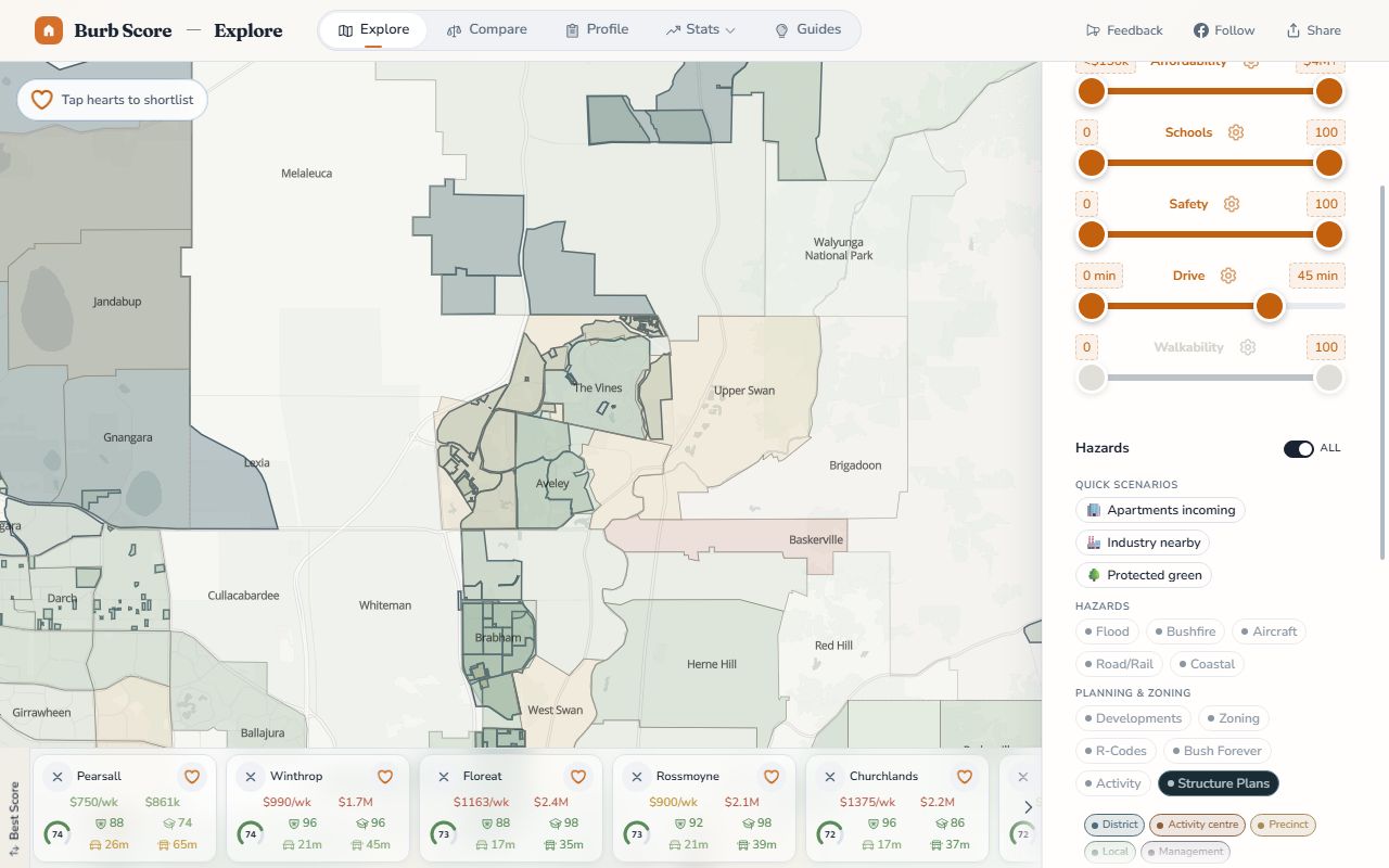
How do I check the zoning of any Perth suburb?
Open the BurbScore map and switch on the R-Codes layer. Every parcel in the Perth metro area is coloured by its density code, dual codings included, and the zoning and structure plan layers sit alongside it, so you can cross-check land use and future density in the same view.
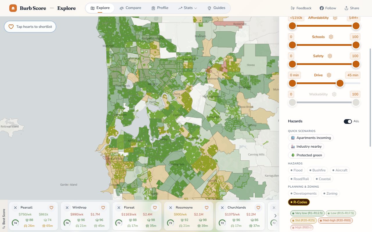
The R-Codes layer colours every parcel by its density code. Click to open the live layer.
The three layers, all recently added to the map (see what's new):
- R-Codes layer: per-parcel density coding across the metro area. Zoom to any street and the split between R20 frontages and R40/R60 pockets is immediately visible.
- Zoning layer: the scheme zones, from residential and commercial to mixed use, industrial and public purposes. Useful for spotting corridor rezonings before they show up in prices.
- Structure plans layer: the approved future-density blueprints over growth areas, so you can see what a paddock is planned to become.
No login, no PDF scheme maps, no guessing which of seventeen council mapping portals covers your suburb. Type an address, toggle the layer, read the code.
If you take one thing away
Treat every R-Code as a question, not an answer. The code tells you the ceiling the planning scheme allows; it says nothing about whether the sewer main reaches the street, whether the block sits on bushfire-prone land, or whether the council's dual-coding conditions are realistic for your site. The gap between "coded R40" and "can actually build four villas" is where buyers overpay, and where sellers' agents do their best work.
The practical workflow is short. Check the code on the R-Codes layer, divide the block size by the average site area to get the paper yield, then run the constraint layers (bushfire, flood, protected land) over the same parcel before you believe the number. If the listing claims dual-coded potential, find the council's local planning policy and read the actual conditions; they vary more than anyone selling you the block will admit. And if you're buying in a growth corridor, the structure plan over the land tells you more about 2036 than the current zoning does.
We keep the planning layers on our map updated from the state's official scheme data, so what you see is what the council sees, without the scavenger hunt through scheme maps and PDF appendices. Zoning isn't the most glamorous data layer we publish, but it's the one that decides whether your block is a home, a duplex site, or six villas waiting for paperwork. Worth ten seconds to check before you sign anything.
Data & methodology
Zoning, R-Code and structure plan boundaries shown on the BurbScore map are sourced from Western Australian planning scheme spatial data published by the Department of Planning, Lands and Heritage via Landgate's Shared Location Information Platform (SLIP), and displayed per parcel. Site-area figures in the table above are taken from the Residential Design Codes Volume 1 (Western Australian Planning Commission / DPLH), formerly State Planning Policy 7.3. We used Version 3, published 10 April 2026, and verified the figures against the document's site-area requirements table (Table D) in June 2026. Dwelling-yield examples assume the average site area governs, per the codes; individual proposals may be affected by local planning policies and scheme provisions. Structure plan context draws on the WAPC's WA Planning Manual guidance and DPLH's Urban Development Program publications.
Nick Lilleyman
Founder & Data Lead, Burb Score
Nick built Burb Score to give Perth families a data-driven view of where to live. He works directly with the ACARA, WA Police, ABS Census, WA Rental Bonds and real estate datasets that power every ranking on this site. Rankings are generated programmatically from official data sources, not opinions, and refresh automatically. No sponsored content or paid placements.
Frequently asked questions
Can I subdivide an R20 block?
Only if it's big enough. R20 requires an average site area of 450m² per dwelling and a minimum of 350m², so two lots need roughly 900m² of land, the classic full-size quarter-acre-era block. A 700m² R20 block clears the minimums but fails the average test and stays single-dwelling. Corner blocks and battleaxe configurations follow the same arithmetic; the shape changes the design, not the yield.
How do I find the R-Code of my property?
Toggle the R-Codes layer on the BurbScore map and zoom to your address. Every metro parcel is coloured by code, including dual codings like R20/40. The authoritative source is your council's local planning scheme map, but the map layer shows the same scheme data without hunting through council mapping portals.
Can a council change my R-Code?
Yes, through a local planning scheme amendment: council resolution, public advertising where affected owners can make submissions, and final approval by the Minister for Planning. The process typically takes one to two years. Codes move up far more often than down, usually around train stations, activity centres and corridors targeted for infill, and an upcoding generally lands as a windfall for existing owners.
Does higher density zoning increase property value?
Usually, but not automatically. A higher code adds value only where the extra dwellings are actually buildable and profitable, which depends on sewer availability, block dimensions, construction costs and end-sale prices in that suburb. An R40 coding in a suburb where villas sell below build cost is worth little. Where the numbers work, developers pay a measurable premium for upcoded land, and the market prices it in quickly.
What is R-AC zoning?
R-AC codes are the Residential Design Codes' activity-centre codes, applied in and around town centres, station precincts and the CBD. They allow the highest residential densities in WA: apartments in R-AC areas are assessed under R-Codes Volume 2 (the apartment design code), while any single houses or grouped dwellings on R-AC land default to R80 site-area standards. If your suburb's centre is coded R-AC, expect apartments, not villas.
What changed in the 2024–2026 R-Codes amendments?
The medium-density reforms. The R-Codes moved from State Planning Policy 7.3 to a standalone Planning Code in April 2024, adding Part C medium-density design standards for grouped dwellings at R30+ and small apartment projects. Transitional arrangements ended on 10 April 2026. Since then, single houses in areas coded R50 and above are also assessed under the Part C standards.
Continue your research