Check Any Perth Address for Flood, Bushfire & Noise Risk
Five separate hazards can quietly shape what a Perth property costs to build on, insure, and live in: flood, bushfire, aircraft noise, road and rail noise, and planned development next door. Checking all five currently means visiting five separate government websites: DWER's floodplain maps, the DFES bushfire-prone map, Airservices ANEF charts, the SPP 5.4 corridor data, and the WA Urban Development Program. Each has its own viewer, its own jargon, and its own idea of what a usable map looks like.
Here's the part that surprises people moving from over east: in WA, nobody is obliged to tell you any of this. Western Australia has no mandatory vendor disclosure statement. The seller doesn't have to mention that the block sits in a designated bushfire-prone area, falls inside a mapped floodplain, or lies under an ANEF noise contour. Caveat emptor is alive and well west of the border. Agents and sellers can't mislead you, and they must answer honestly if you ask directly, but the burden of asking is entirely yours.
This guide walks through how to check each hazard on its official source, what each designation actually triggers (in dollars, mostly), and how to check all five in one tap at the end.
How do I check if a Perth property is in a flood zone?
Search the Department of Water and Environmental Regulation's floodplain mapping, which maps the 1-in-100-year (1% AEP) flood extent for WA's major rivers and watercourses, or toggle the flood layer on the BurbScore hazard map. In our database, 122 WA suburbs contain at least some mapped flood-zone land.
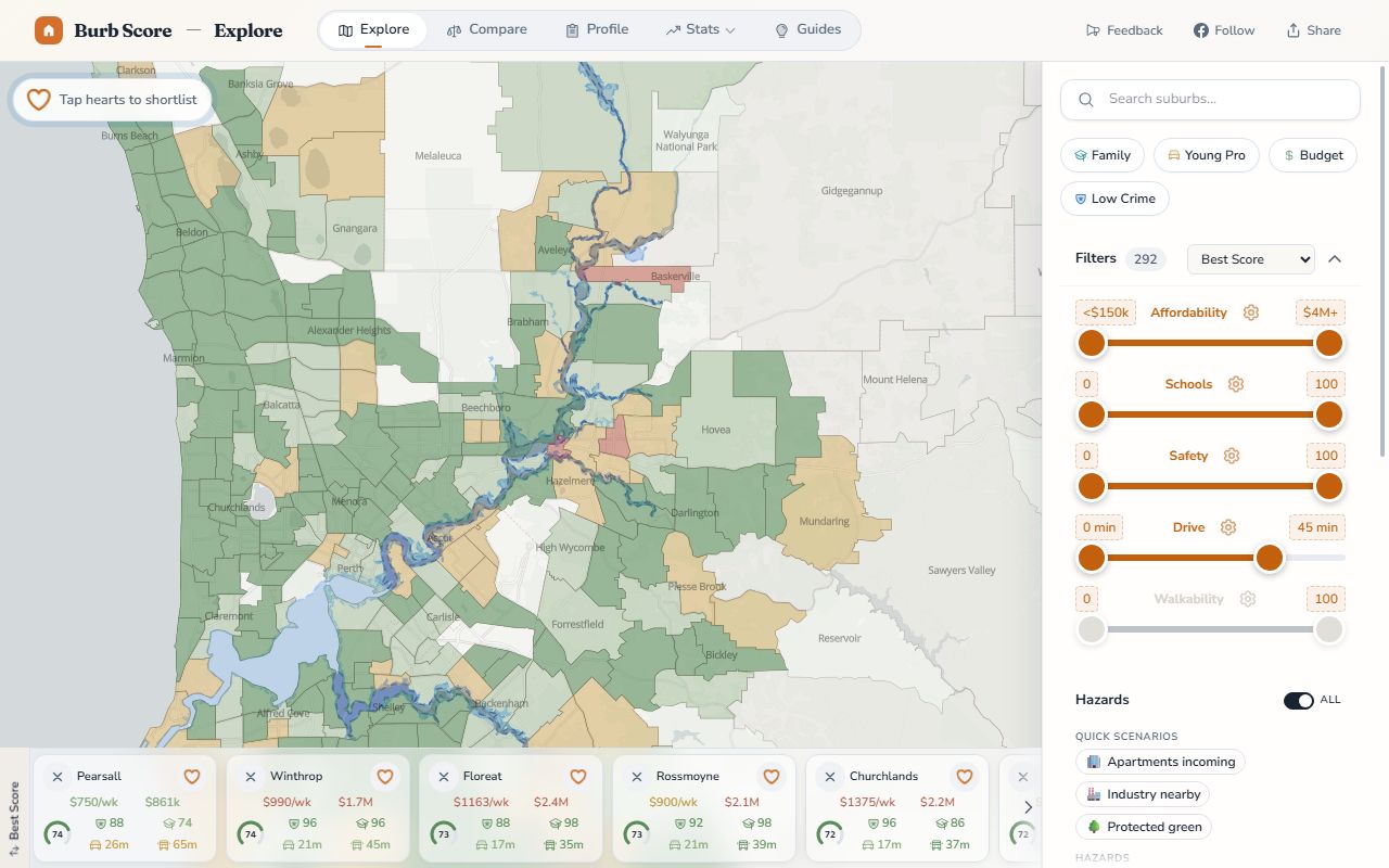
The flood layer over the Swan and Helena rivers. Click to open the live layer.
DWER's floodplain mapping covers the Swan, Canning, Helena, Avon and most major regional rivers. The maps split the 1% AEP floodplain into two zones, and the distinction matters more than the word "floodplain" itself:
- Floodway: the river channel plus the land that carries significant flow during a flood. DWER's position is blunt: development that obstructs flow is not acceptable here, because it pushes flood levels onto everyone upstream. No new buildings, full stop.
- Flood fringe: the edge of the floodplain, generally covered by still or slow-moving water in a 1% AEP event. Development is usually acceptable with conditions, most commonly habitable floor levels set above the flood level with a freeboard margin.
The practical consequences come in two flavours. Insurance: insurers price flood risk at the individual-address level using their own models, but a mapped floodplain address will usually see materially higher flood premiums, and some policies exclude flood cover entirely. Get a quote before you offer, not after. Development approval: councils refer floodplain applications to DWER for advice, and conditions like raised floor levels, fill restrictions or outright refusal (in the floodway) flow from that advice. If you're buying to demolish and rebuild, a flood fringe block changes your slab height and your budget.
One trap worth flagging: no mapping is not the same as no risk. DWER maps rivers and major watercourses, not every drainage line in the metro area. Localised stormwater flooding sits with councils and the Water Corporation, and it won't appear on the floodplain maps at all. If a block sits low, near a sump, or at the bottom of a long street, ask the council about local drainage history even when the DWER layer is clear.
How do I check if a property is bushfire prone in WA?
Check the DFES Map of Bush Fire Prone Areas, the statutory map of designated bushfire-prone land in Western Australia, or toggle the bushfire layer on the BurbScore map. Designation is common: 410 of the roughly 1,600 WA suburbs in our dataset contain at least some bushfire-prone land.
Bushfire prone areas (DFES) across the Perth Hills. Click to open the live layer.
The DFES map is a legal trigger, not just an advisory layer. If land is designated bushfire-prone, building a new dwelling (or doing substantial work on an existing one) requires a Bushfire Attack Level (BAL) assessment, and the resulting rating dictates construction standards under AS 3959:
- BAL-Low: no special construction requirements
- BAL-12.5 and BAL-19: ember protection (sealed gaps, ember-resistant vents, screened openings)
- BAL-29: higher radiant heat exposure, requiring upgraded glazing, cladding and insulation
- BAL-40 and BAL-FZ (Flame Zone): direct flame contact expected, which means non-combustible construction, certified building systems, and at Flame Zone, often additional planning controls on top
The rating itself is driven by three site factors: the classification of nearby vegetation (forest rates worse than grassland), the slope under that vegetation (fire runs uphill), and the distance from the vegetation to the building. That's why two lots in the same designated suburb can land on completely different BALs. A cleared lot in the middle of a subdivision might assess at BAL-Low, while a block backing onto a wooded gully two streets away comes in at BAL-40.
Each step up the scale adds real money. Toughened glass, non-combustible cladding and sealed roof systems are not cheap line items, and at BAL-40 or FZ the premium over a standard build can be substantial. The designation also follows you into renovations and extensions, not just new builds. If you're comparing blocks in the hills or on the urban fringe, treat a BAL assessment as part of the purchase cost. To see which suburbs carry the most exposure, start with our ranking of Perth's most bushfire-prone suburbs.
What is an ANEF contour and which Perth suburbs are affected?
An ANEF (Australian Noise Exposure Forecast) contour is a forecast aircraft-noise map endorsed by Airservices Australia and used for land-use planning around airports. Perth has two contour sets: Perth Airport and Jandakot. In our data, 35 Perth metro suburbs intersect an ANEF contour from one of those two airports.
Airservices Australia endorses the technical accuracy of every ANEF; the WA government then bakes the Perth Airport contours into State Planning Policy 5.1 to restrict incompatible development around the airport. The numbers on the contours map to acceptability rules for new houses under AS 2021:
| ANEF zone | New house under AS 2021 | In practice |
|---|---|---|
| Below 20 | Acceptable | No aircraft-noise construction requirements |
| 20 to 25 | Conditionally acceptable | External walls, windows and roof must be built to attenuate aircraft noise to AS 2021 levels, an acoustic construction cost |
| Above 25 | Unacceptable | New dwellings generally not supported, though planning authorities retain some discretion where construction achieves the required noise reduction |
Two caveats worth knowing. First, an ANEF is a forecast of long-term average exposure, not a measurement of today's flights. A property outside every contour can still sit under a busy departure track. If you want to see actual flight tracks over a specific address, Airservices' WebTrak tool replays real movements; spend ten minutes on it for any property east or south-east of the city before you trust the contour alone. Second, the contours follow runway alignments, not suburb boundaries, so exposure within a single suburb varies street by street. You can see the exact contour over any address on the BurbScore aircraft noise map, and we've ranked which suburbs intersect the contours, and by how much, in our companion piece on Perth's flight path and aircraft noise suburbs.
What are road and rail noise corridors?
Road and rail noise corridors are buffer areas around major transport routes defined under WA State Planning Policy 5.4. Inside a corridor's trigger distance, new noise-sensitive development (houses, schools, hospitals) must assess and attenuate transport noise. In our data, 375 metro suburbs touch at least one SPP 5.4 corridor. You can trace where the corridors run over any address on the BurbScore road and rail noise layer.
SPP 5.4 works in both directions: it protects residents from unreasonable transport noise, and it protects the state's freight and passenger corridors from being hemmed in by noise complaints. Three points matter for a buyer:
- It applies to new development. A new house, subdivision or major redevelopment inside the trigger distance needs a noise assessment, and individual lots can carry "quiet house" treatment requirements: packages of escalating acoustic specs for walls, glazing and outdoor living areas.
- It does not retrofit existing homes. The policy doesn't apply to noise from an existing road or railway near an existing house. If you buy 80 metres from the freight line, the noise is yours, and no agency is obliged to attenuate it.
- Corridors are wide. 375 metro suburbs touching a corridor sounds alarming until you remember the trigger distances along major roads and rail run to hundreds of metres. The point isn't to avoid every corridor suburb; it's to know whether a specific lot falls inside one before you design a build or price a renovation.
How do I see planned developments near a property?
The WA Urban Development Program (UDP) publishes the pipeline of planned residential development across Perth and Peel, showing where new lots, apartments and infill density are expected over the coming years. BurbScore's developments layer puts that pipeline on the same map as the four hazards above.
Upcoming density cuts both ways. A major structure plan two streets away can mean years of construction traffic, a changed streetscape and more competition for the local school. Or it can mean a new train station, better shops and the strongest price growth in the area. Either way, you want to know before you sign, not when the hoarding goes up. We ranked where the pipeline is concentrated in the Perth suburbs with the biggest development pipelines.
Development potential on the lot itself is a separate question: that's zoning, governed by R-Codes rather than the UDP. If you want to understand what an R20 or R60 code means for the block you're buying, and the blocks around it, see our sister guide to R-Codes and zoning in WA.
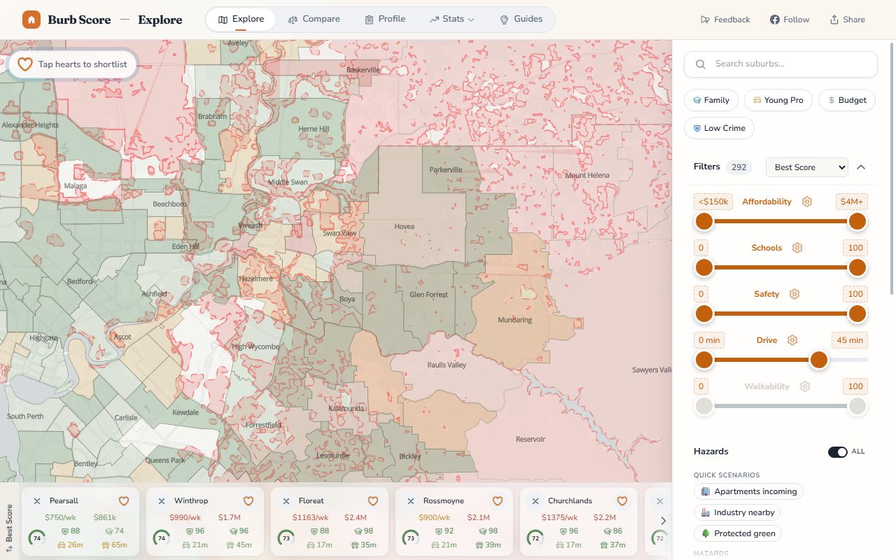
How do I check all five hazards at once?
Open the BurbScore hazard map with all five layers switched on, then type any address into the search box. The map zooms to the property and shows every mapped hazard around it in one view: flood, bushfire, aircraft noise, road and rail corridors, and the development pipeline.

All five hazard layers switched on at once. Click to open the live map.
A few things that make this faster than the five-portal crawl:
- Master toggle. The hazards control turns all five layers on or off at once, or you can flick individual layers to isolate one, which is useful where overlays stack up in an area that has several.
- Address search. Type the street address straight from the listing. You don't need to know which suburb the lot falls in or which agency's map covers it.
- Suburb hazard panels. Every suburb page carries a hazards panel summarising the same layers for the whole suburb. See Lesmurdie for what a heavily bushfire-prone hills suburb looks like.
The map is a screening tool. It tells you in ten seconds whether a hazard question exists for a property; the statutory sources above tell you exactly what it means for your approval, your build spec and your premium.
If you take one thing away
WA's property system assumes you'll do your own homework, and the homework is genuinely doable in an afternoon. Screen the address on the BurbScore hazard map first; ten seconds tells you which of the five questions even apply. Then confirm anything that lights up against the statutory source: DWER for flood, DFES for bushfire, the ANEF charts for aircraft noise, the SPP 5.4 mapping for corridors. Finally, price the consequence before you make the offer: a flood-cover quote for a fringe block, a rough BAL construction premium for a hills build, an acoustic package for a corridor lot. Hazards rarely kill a purchase. Unpriced hazards kill budgets.
What this guide doesn't cover
Contaminated sites, acid sulfate soils, heritage listings, Aboriginal heritage places and mining tenements are all real due-diligence items with their own registers; they're just not layers on our map yet. Coastal erosion mapping is another moving target. And nothing here substitutes for the formal assessments councils and insurers actually act on: a BAL assessment from an accredited practitioner, written flood advice from DWER via your council, or an acoustic report from a qualified consultant. The maps tell you which of those to commission; they don't replace them.
The hazard layers refresh on a rolling schedule as the source agencies republish their data. See the updates page for what changed and when, and once you've narrowed a shortlist, you can compare suburbs side by side on the stats that matter to you.
Data & methodology
Hazard layers are sourced from the authoritative WA datasets: the DFES Map of Bush Fire Prone Areas, DWER floodplain mapping (1% AEP floodway and flood fringe areas), Perth Airport and Jandakot ANEF contours endorsed by Airservices Australia, road and rail noise corridors defined under SPP 5.4 (Main Roads WA and PTA routes), and the WA Urban Development Program pipeline, all accessed via Landgate's SLIP platform. Suburb-level figures (410 suburbs with bushfire-prone land, 122 with flood-zone land, 35 with ANEF exposure, 375 metro suburbs touching a noise corridor) are spatial intersections of each hazard layer against suburb boundaries, computed by our data pipeline across all WA suburbs, metro and regional. Figures current as at June 2026.
Nick Lilleyman
Founder & Data Lead, Burb Score
Nick built Burb Score to give Perth families a data-driven view of where to live. He works directly with the ACARA, WA Police, ABS Census, WA Rental Bonds and real estate datasets that power every ranking on this site. Rankings are generated programmatically from official data sources, not opinions, and refresh automatically. No sponsored content or paid placements.
Frequently asked questions
Do sellers have to disclose flood or bushfire risk in WA?
No. Western Australia has no mandatory vendor disclosure statement, so a seller is not required to volunteer that a property is bushfire-prone or sits in a mapped floodplain. Agents and sellers can't mislead you under Australian Consumer Law (and must answer honestly if asked directly), but the onus to ask, and to check, sits with the buyer.
Does being in a bushfire prone area increase insurance?
Often, but indirectly. Insurers price bushfire risk at the address level using their own models rather than the DFES map itself, so designation and premium don't move in lockstep. The more certain cost is construction: a designated lot requires a BAL assessment, and any rating above BAL-Low triggers AS 3959 build requirements that add cost to a new build or major renovation.
Can I build in a flood fringe area?
Generally yes, with conditions. Flood fringe is the part of the 1% AEP floodplain covered by still or slow-moving water, and development there is typically acceptable subject to requirements like habitable floor levels set above the flood level. The floodway is the opposite case: new buildings there are not acceptable because they obstruct flood flows.
What ANEF level is too noisy for a house?
Under AS 2021, new houses are acceptable below ANEF 20, conditionally acceptable between 20 and 25 (the building must be constructed to attenuate aircraft noise), and unacceptable above 25. Keep in mind an ANEF is a long-term forecast of average exposure. Properties outside every contour can still experience regular overflights.
Are hazard maps definitive?
No, they're screening tools. The statutory maps are updated periodically and drawn at scales that can't capture every individual lot perfectly, and our layers inherit those limits. Use the map to work out which questions to ask, then confirm with the source agency and, where money rides on it, a site-specific assessment from a qualified consultant.
Can I check a specific address rather than a whole suburb?
Yes. The hazard map's search accepts street addresses: it zooms to the lot and overlays whichever hazards are mapped around it. Suburb pages summarise the same layers at suburb level, which is useful for shortlisting, but for a contract decision always check the address itself, because hazard boundaries cut through suburbs constantly.
Continue your research